
Home > Biology and biodiversity > Deepwater communities > Ningaloo deep water biodiversity benthic sled survey
Ningaloo deep water biodiversity benthic sled survey
- AIMS
- AIMS,
- WAMSI,
- Western Australian Museum
Existing towed video footage and single beam sonar data allowed for the detection and targeting of
different benthic communities with the benthic sled, so species and functional groups could be identified (Western Australian Museum) and their distribution, abundance, biomass and size composition investigated. Due to the large size of some of the benthos collected (i.e. sponges and gorgonians) in the 2006 field work the CSIRO designed benthic sled was sometimes inadequate dimensions for the purposes of our survey and a new sled was designed and built for the 2007 field work.
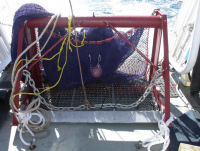
The new steel benthic sled is based on the design of a commercial fishing Tri-gear Trawl Beam, slightly modified for our purposes (Fig.16). Traditionally a Tri-gear Trawl Beam is used to locate, track and sample scallops and deep water prawns in depths less than 1000 metres. The dimensions of the sled used at Ningaloo are 1.5 m wide x 1 m high. The net and cod end (Fig.17) are made of 48 ply 2" AmicanTM. It is a 4 seam net; top and bottom panels 100 meshes wide with wing panels 50 meshes high. It has a 9 bar 1 point taper with panels 75 meshes long with dimensions of 55 meshes long and 100 meshes round. The net and cod end are protected by rubber chafe matting
design to minimise damage from abrasive substrates (i.e. rock, coral). There is a double cod end to help secure the sample from being lost from a torn net.
Twelve benthic sled samples were collected over 4 days in different habitats with varying degrees of benthos (i.e. dense, medium, and sparse). The sled was lowered to the bottom by a winch with steel cable and dragged along the bottom. Distance fished was estimated by the winch operator, recording the GPS position when the sled touches the bottom and when it leaves the bottom. GPS
positions provide the distance travelled in metres of all the samples conducted. To ensure more accurate fishing times for the sled in the future a depth sensor, time synchronised to the ships GPS, will be attached to provide a downloadable profile of fishing time and distance.
Trials indicated the new sleds’ sampling wan an improvement on 2006 and all the macro benthos shown on towed video was being sampled. Trials also indicated that the most representative and manageable sled sample distance, out of several tested, was 50 metres in all the habitats sampled. Fifty metre long samples will be adopted as the standard for future samples to be carried out in 2008. The improved benthic sled design and fishing time/distance measurement capabilities to be fitted before 2008 will Ningaloo Reef MP Deepwater Benthic Biodiversity Survey Metadata Report
30 allow us to quantify more accurately the abundance and biomass of phyla that make up
the benthic communities in different areas of the marine park.


