Home > Biology and biodiversity > Coral reefs > Reef fish communities > Surveys of deep water benthic fish and elasmobranchs using stereo-BRUVS.

Surveys of deep water benthic fish and elasmobranchs using stereo-BRUVS.


Posted on 22 January 2013

  • Mark Case
  • AIMS,
  • UWA


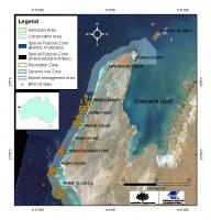
The aim of this research was to characterize the structure and distribution of deepwater fish assemblages (greater than 10 m depth) outside the crest of the Ningaloo Reef and to provide information about the diversity, spatial distribution and habitat affiliation of demersal fin fishes across a range of depths and habitats within the northern section of Ningaloo Marine Park.

This field survey was planned around the outcomes of the towed video and acoustic survey undertaken by AIMS staff and FUGRO in April of 2006. The towed video and acoustic survey provided information on the distribution of benthic habitats in the area between the 15 and 100 m depth contours and allowed us to target sampling within specific habitats and depths. Within these areas a number of random samples were allocated. Sampling occurred in five areas including Mandu, Osprey and Cloates Sanctuary Zones, and Osprey and Cloates reference areas. 185 stereo-Baited Remote Underwater Video System (stereo-BRUVS) samples in total were collected.

  • Mark Case
Custodian(s)
  • AIMS
  • UWA
Owner Institution(s)

Interrogation of each tape was conducted using a custom interface (BRUVS1.5.mdb©, Australian Institute of Marine Science 2006) to manage data from field operations, tape reading, capture the timing of events, capture reference images of the seafloor and fish in the field of view. The following data were recorded for each species; the time of first sighting, time of first feeding at the bait, the maximum number seen together at any one time on the whole tape (MaxN), time at which MaxN occurred, and any intraspecific and interspecific behaviour. The use of MaxN as an estimator of relative abundance has been reviewed in detail by Cappo et al. (2003, 2004). Estimates of MaxN are considered conservative, particularly in areas where fish occur in high densities.

Data Units
-21.5, 113.5, -23.0, 114.5
Region & Spatial Extent
2006
Data Collection
Completed
Maintenance & Update Frequency
All AIMS data, products and services are provided "as is" and AIMS does not warrant their fitness for a particular purpose or non-infringement. While AIMS has made every reasonable effort to ensure high quality of the data, products and services, to the extent permitted by law the data, products and services are provided without any warranties of any kind, either expressed or implied, including without limitation any implied warranties of title, merchantability, and fitness for a particular purpose or non-infringement. AIMS make no representation or warranty that the data, products and services are accurate, complete, reliable or current.To the extent permitted by law, AIMS exclude all liability to any person arising directly or indirectly from the use of the data, products and services. Ownership of all Intellectual Property Rights in the data remains with the Australian Institute of Marine Science (AIMS) and all use of the data must acknowledge AIMS. All users of AIMS data must acknowledge the source of the material in the following manner: "Data was sourced from the Australian Institute of Marine Science (AIMS)."
Resource Constraints

Format for citation of data sourced from Australian Institute of Marine Science (AIMS) in a list of reference is as follows: "Australian Institute of Marine Science. [year-of-data-download], [Title], [data-access-URL], accessed (date-of-access]".

References
Ning_AIMS_BRUVS-2006
Dataset Short Name
Google Earth Data
Reports
Data