
Home > Browse by Institution > Geoscience Australia > A physical and biological survey of the Carnarvon Shelf off Ningaloo
A physical and biological survey of the Carnarvon Shelf off Ningaloo
- Geoscience Australia,
- Australian Institute of Marine Science
- Geoscience Australia,
- Australian Institute of Marine Science
Detailed surveys of three sites on the Carnarvon Shelf (Mandu Creek, Point Cloates, Gnaraloo) were undertaken onboard the RV Solander between August and September 2008 to collect high quality data to facilitate the robust testing of physical parameters as potential surrogates of benthic biodiversity. As such, both physical (wave and current measurements, multibeam sonar bathymetry and backscatter, sediment grab samples, acoustic sediment profiles) and biological (towed underwater video and still photography, bottom sediment samples, near-bottom plankton surveys) data were collected for comparative analyses. A post-survey report (Brooke et al. 2009) was produced that describes the survey methods and provides initial interpretations of the physical data and biota encountered, as a precursor to additional data analyses to allow for the comparative analyses.
High resolution multibeam sonar mapping revealed that the continental shelf extends further offshore as you move north to south along the Ningaloo Coast. The continental shelf is approximately 7.5 km wide at Mandu Creek, approximately 20 km wide at Point Cloates, and approximately 32 km wide at Gnaraloo (Figure 1A). Water depths along the Ningaloo Coast at these three locations ranged from 10 m to 150 m (Figure 1A), and the slope was divided into an inner shelf, mid shelf, and outer shelf.
| click image for larger image view |
 |
Figure 1. A. Multibeam coverage of the Carnarvon Shelf showing bathymetric profiles at Mandu Creek, Point Cloates, and Gnaraloo with inner shelf (a), mid shelf (b) and outer shelf (c) indicated. B. Sediment size classes of surface sediments at Mandu Creek, Point Cloates, and Gnaraloo. Data extracted from Brooke et al. 2009. |
The most complex seabed habitat occurred on the inner shelf where ridges, mounds, and raised hard ground produce a highly rugose shelf. The surface sediments of the shelf at Mandu Creek and Point Cloates range from sand to gravel, whereas sand dominates the shelf at Gnaraloo (Figure 1B). Towed underwater video and still photography revealed mixed assemblages along the Carnarvon Shelf, including hard corals, sponge gardens, rhodolith beds, bioturbated sediments, and comparatively barren sand (Figure 2). The amount of rhodoliths decreased from north to south, while the amount of sponges was highest in the south at Gnaraloo.
| click image for larger image view |
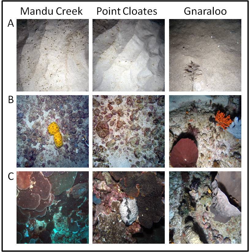 |
Figure 2. Still photographs of benthic habitat examples at Mandu Creek, Point Cloates, and Gnaraloo on the Carnarvon Shelf. A. Sand. B. Rhodolith bed. C. Reef invertebrate communities. Data extracted from Brooke et al. 2009. |
Additional processing of the physical and biological data will provide increased resolution data sets that will be used for comparative analyses of the data sets to feed into the Physical Surrogates for Biodiversity Program.
For more detailed information on this study, see Brooke B, Nichol S, Hughes M, McArthur M, Anderson T, Przeslawski R, Siwabessy J, Heyward A, Battershill C, Colquhoun J and Doherty P (2009), or contact the corresponding author, Dr Brendan Brooke.
Dataset details
| Custodian | Dr Brendan Brooke |
| Owner institution | Geoscience Australia (http://www.ga.gov.au/) |
| Spatial extent | Mandu (22° 10' S, 113° 47' E), Point Cloates (22° 30' S, 113° 33' E), Gnaraloo (23° 19' S, 113° 31' E) |
| Data collection | August 2008 to September 2008 |
| Copyright | Copyright remains with the data owner(s) |
| Reference | Click here |


