Home > Browse by Institution > Western Australia Department of Environment and Conservation > Ningaloo Marine Park zoning
Ningaloo Marine Park zoning
- Western Australia Department of Environment and Conservation
- Western Australia Department of Environment and Conservation
The Ningaloo Marine Park stretches approximately 300 km along the west coast of the Cape Range Peninsula near Exmouth, Western Australia – from Bundegi in the north to Red Bluff in the south. The Ningaloo Marine Park consists of both State and Commonwealth Waters, which are declared under Western Australian and Commonwealth legislation. The combined State and Commonwealth Waters of the Ningaloo Marine Park cover a total area of 5070 km2.
The Ningaloo Marine Park is a multiple-use Marine Park that caters for a wide range of activities. Multiple-use Marine Parks reflect a balanced approach to conserving the environment by providing a management framework to ensure human usage does not cause significant or long term damage. Zoning is an important part of the management framework in multiple-use Marine Parks because a healthy and productive Reef means substantial economic benefits to local communities and the wider economy.
Zoning in the Ningaloo Marine Park
Marine Park zoning is an important component in managing marine areas, and zoning is a key strategy for improving the health and resilience of Ningaloo Reef. The zoning plan defines what activities can occur in which locations in order to protect the marine environment and to separate potentially conflicting activities.
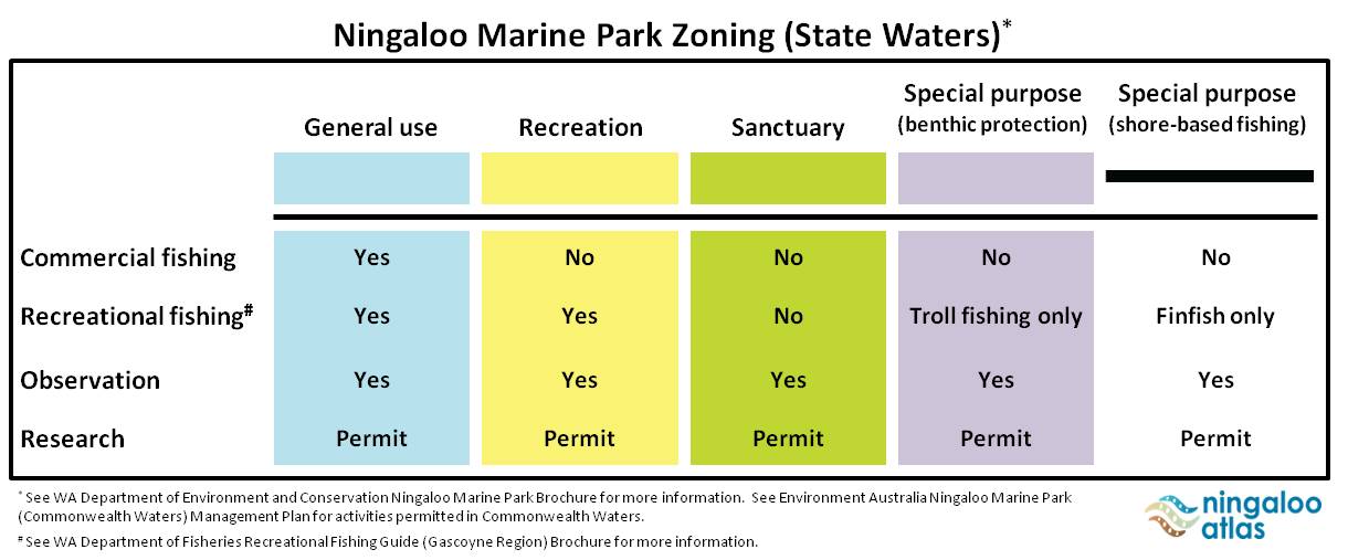
In its simplest form, zoning defines the activities that can occur in particular locations. Within the Ningaloo Marine Park (State Waters) there are currently five different types of zones (Figure 1; see Google Earth layer below), whereby the level of protection increases from the General use (light blue) zones up to the most restrictive Sanctuary (green) zones. Each zone has different rules for the activities that are allowed, the activities that are prohibited, and the activities that require a permit.
It has been proposed that 20% to 50% of marine habitats are protected in no-take areas. Currently, 34% of the area in the Ningaloo Marine Park are no-take Sanctuary (green) zones, which is similar to the 33% no-take zones of the Great Barrier Reef Marine Park.
Fishing is permitted in the Ningaloo Marine Park but rules apply - refer to the Recreational Fishing Guide: Gascoyne Region.
| click image for larger image view |
 |
Figure 1. Five different zones currently in the Ningaloo Marine Park (State Waters). |
The Ningaloo Marine Park Zoning Plan better protects the biodiversity within the Marine Park and helps ensure:
- The continued existence of the unique marine animals, plants and habitats that are found along the Ningaloo Coast, and provide additional protection for threatened species such as dugong and marine turtles.
- Those industries that rely on the health of the Marine Park are able to continue, providing social and economic benefits to local communities and the wider economy.
- That a diverse range of other benefits and values of the Marine Park, including recreational, cultural, educational and scientific values are protected.
- That future generations are able to continue to use and enjoy the Marine Park.
The information provided here (including the Google Earth layer below) is provided only as a guide, and does not replace the Western Australia Department of Environment and Conservation, Western Australia Department of Fisheries, and the Commonwealth of Australia rules and regulations. See Ningaloo Marine Park for the respective government agency brochures on the Ningaloo Marine Park.
Dataset details
| Owner institution | Western Australia Department of Environment and Conservation (http://www.dec.wa.gov.au/) |
| Spatial extent | Muiron Islands (21° 39' S, 114° 22' E) to Red Bluff (24° 01' S, 113° 25' E) |
| Copyright | Copyright remains with the data owner(s) |
| Reference | Click here |


