
Home > Browse by Themes > Human use > Offshore petroleum exploration acreage releases
Offshore petroleum exploration acreage releases
- Department of Resources, Energy and Tourism
- Department of Resources, Energy and Tourism
The oil and gas industry is a major contributor to the Australian economy. In 2006/7 the industry accounted for about 3.8 % of the total Gross Domestic Product and generated estimated revenue of A$39.1 billion and A$33.6 billion, respectively. As such, the Australian Government encourages investment in petroleum exploration through the annual release of offshore petroleum exploration acreage.
The annual offshore petroleum exploration acreage release is a key part of the Australian Government’s strategy to encourage further petroleum exploration in Australia’s offshore waters. The regular release of acreage enables industry to undertake longer term planning and provides certainty in the release process. The release is supported by a comprehensive information package that ensures access to pre-competitive geological and geophysical data and analysis, along with the provision of quality information about issues that may impact on successful applicants. All release areas are supported by pre-competitive geological and geophysical data and analysis undertaken by Geoscience Australia and are selected to offer the global petroleum exploration industry a variety of investment opportunities, with areas varying in size, level of existing geological knowledge, and different water depths.
The Southern Carnarvon Basin and the Northern Carnarvon Basin are the two major release areas off the Ningaloo Coast. The Southern Carnarvon Basin is a large (192,000 km2) predominantly onshore-offshore sedimentary basin that lies to the south of the Northern Carnarvon Basin. The Southern Carnarvon Basin comprises the Gascoyne, Merlinleigh, and Byro sub-basins, and the Bernier Platform (Figure 1). The Northern Carnarvon Basin is predominately offshore and much larger (535,000 km2) than the Southern Carnarvon Bain, and represents one of Australia’s most explored and prospective basins. The Northern Carnarvon Basin comprises the Exmouth, Barrow, Dampier and Beagle sub-basins, the Exmouth Plateau, and the Rankin Platform (Figure 1).
| click image for larger image view |
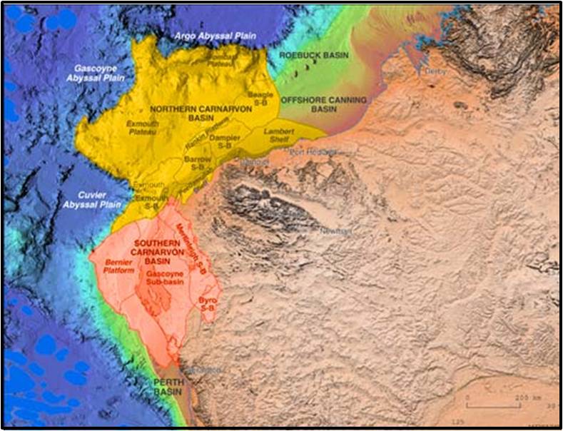 |
Figure 1. Northern Carnarvon Basin and Southern Carnarvon Basin showing the locations of the sub-basins and platforms. Image: Geoscience Australia. |
See the Google Earth layer below to access the offshore petroleum exploration acreage releases for 2008 to 2011 for the Southern Carnarvon Basin and the Northern Carnarvon Basin.
For more detailed information on offshore petroleum exploration acreage releases see the Department of Resources, Energy and Tourism.
Dataset details
| Owner institution | Department of Resources, Energy and Tourism (http://www.ret.gov.au) |
| Spatial extent | Northern Carnarvon Basin (16° 29' S) and Southern Carnarvon Basin (25° 24' S) |
| Data collection | 2008 to 2011 |
| Copyright | Copyright remains with the data owner(s) |
| Reference | Click here |


